Oppdateringer
Her kommer oppdateringer om aktiviteten
Følg med på vår SMS-varsling for oppdateringer om veistenging. Se beskrivelse for abonnering på SMS-varslingen i teksten under.
Updates
Updates about the activity will be published here
Follow our SMS service (in Norwegian only) for updates about road closure. To subscribe, see description below.
English text (click to expand)
Andøya Space hereby informs about planned launch activity in Børvågen from September 4th to 10th, 2026, with planned road closure from 17:00 to 01:00 local time.
Launch activity and road closure
The activity will take place from Børvågen in the period between September 4th to 10th 2026.
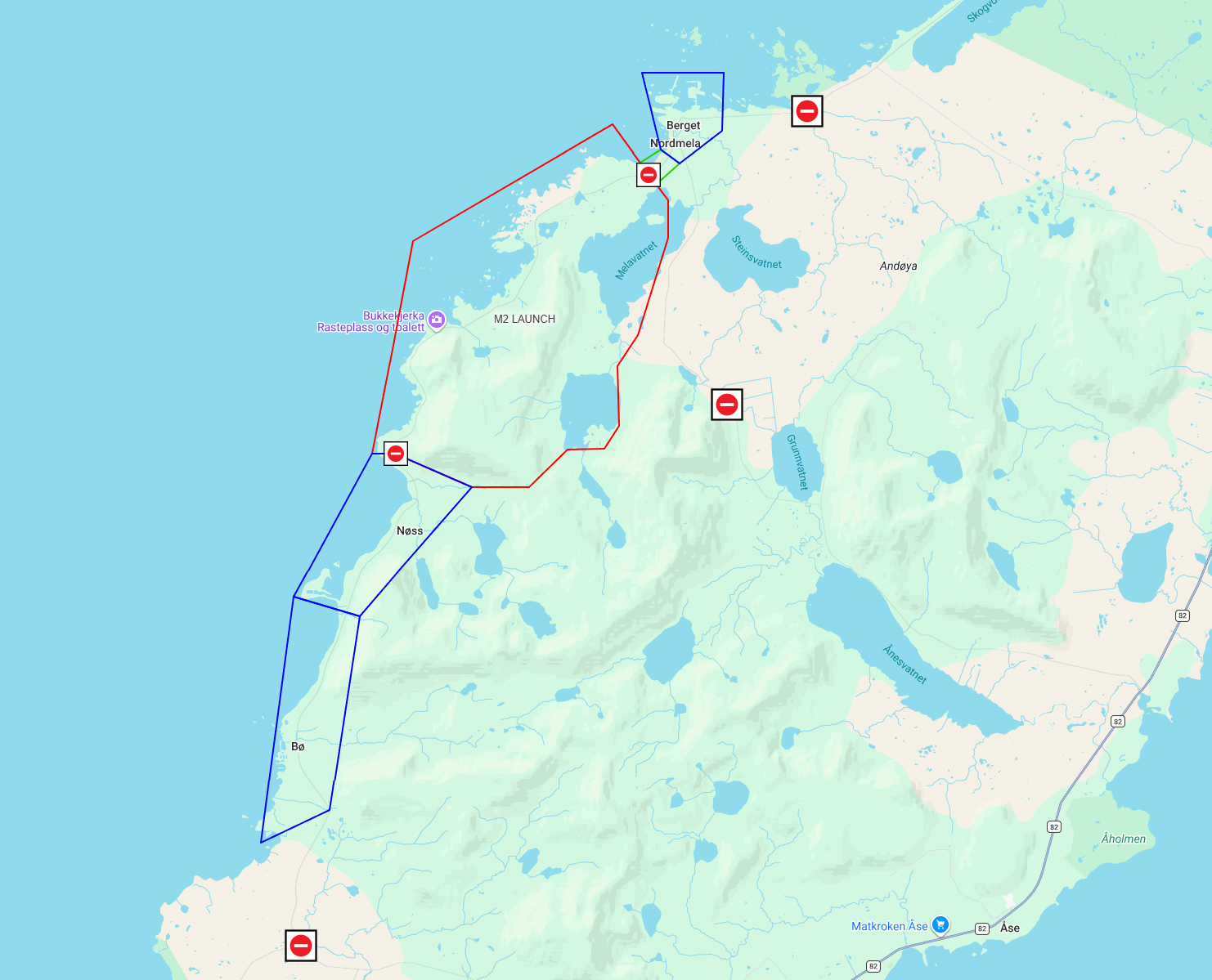
County Road 7698 may be closed between Nordmela and Nøss in connection with the activity between 17:00 and 01:00 local time. See picture and description of road closure under “danger area land, including limited capasity zones” below.
Danger areas
Danger areas will be activated, cleared and closed to unauthorized personnel until the activity has been concluded. The following danger areas will be established in connection with the launch: danger area land, danger area sea inner and danger area sea outer. Click on the different danger areas below for more information:
Danger area land, including limited capacity zones
In accordance with our safety procedures, the number of people present in areas close to the danger area must be kept to a minimum. These areas with limited capacity are referred to as “limited capacity zones.”
These zones are reserved for permanent residents, and we kindly ask everyone else to remain outside these zones. See the figure below for details about the danger area during launch (red) and the limited capacity zones (blue).
Danger area sea inner, “SEA_UR”
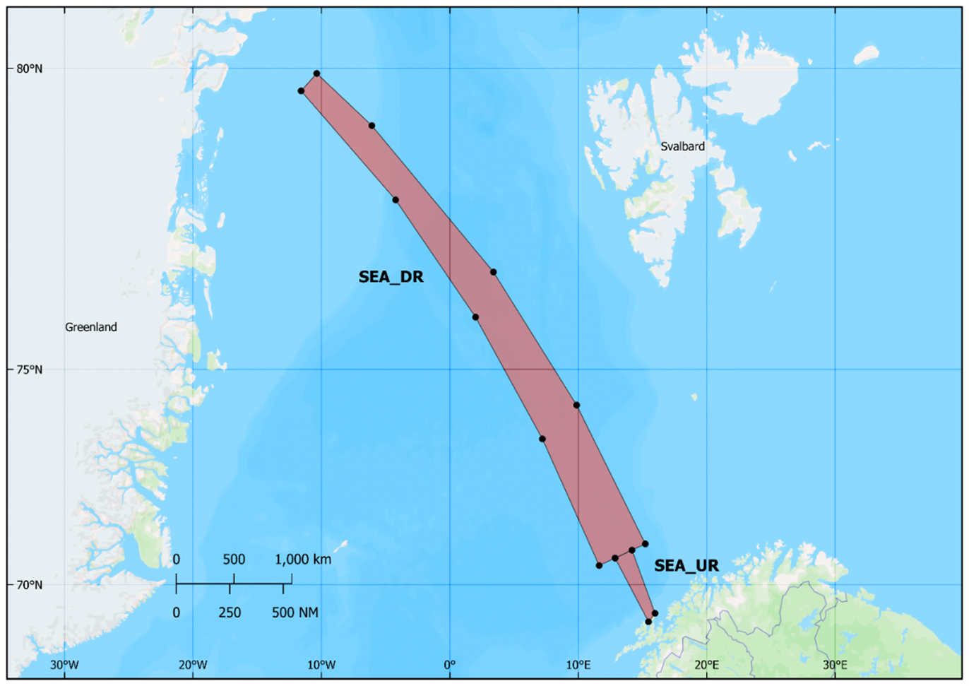
The danger areas at sea consists of two areas, inner “SEA_UR” and outer “SEA_DR”.
| Coordinate number | Coordinate Lat-Lon (DDMM.M) |
|---|---|
| 1 | 6947.00N-01533.00E |
| 2 | 6948.00N-01609.00E |
| 3 | 6936.00N-01612.00E |
| 4 | 6935.00N-01538.00E |
| (1) | (6947.00N-01533.00E) |
Danger area sea outer, “SEA_DR”
The danger areas at sea consists of two areas, inner “SEA_UR” and outer “SEA_DR”.
| Coordinate number | Coordinate Lat-Lon (DDMM.M) |
|---|---|
| 1 | 7103.42N-1512.97E |
| 2 | 7415.83N-0952.26E |
| 3 | 7650.36N-0323.81E |
| 4 | 7911.76N-0604.25W |
| 5 | 7955.85N-1021.89W |
| 6 | 7941.45N-1134.89W |
| 7 | 7803.47N-0413.39W |
| 8 | 7601.02N-0200.03E |
| 9 | 7332.12N-0712.24E |
| 10 | 7030.12N-1137.50E |
| (1) | 7103.42N-1512.97E |
Maritime traffic
Andøya Space requests maritime traffic to pay attention to the announced danger area and assist in keeping the area clear during the short period required to carry out the activity.
Danger areas published on Barentswatch are shown in yellow and will change to 4 hours prior to the planned activity. The areas will revert to yellow once the day’s activity is completed and will be removed when the campaign as a whole has ended.
The Maritime Surveillance Officer (MSO) is available for maritime traffic coordination during the launch period. During launch attempts the MSO is on station from 11:00 local time, and may be reached on VHF channel 14 or 16 or by phone + 47 73 60 70 64
MSO are also available for maritime traffic on e-mail: mso@andoyaspace.n
Maritime Traffic
Andøya Space requests maritime traffic to pay attention to the announced danger areas and assist in keeping the area clear during the period required to carry out the activity.
Danger areas published on Barentswatch are shown in yellow and will change to red 4 hours prior to the planned activity. The areas will revert to yellow once the day’s activity is completed and will be removed when the campaign as a whole has ended.
The Maritime Surveillance Officer (MSO) is available for maritime traffic coordination during the launch period. During days of launch attempts the MSO may be reached on VHF channel 14 or 16 or on phone + 47 94 07 59 44. Maritime traffic may also reach MSO on e-mail: mso@andoyaspace.no
Airspace restrictions
The area around the spaceport is a permanent airspace restriction zone, which means that all aircraft must apply for permission to use the airspace by sending an application to air@andoyaspace.no.
Privacy policy
For information about our privacy policy (GDPR), visit: andoyaspace.no/privacy-policy
SMS-service
Road closures and the use of the danger area at sea will be announced both on our website and via our SMS service. The SMS service is free and will send out updates. Note that the SMS only will be sent out on Norwegian. You can also follow updates through the Norwegian Public Roads Administration’s traffic information service and Barentswatch.
Sign-up for road:
Send code word «ANDOYASPACE VEI START» to 27222 to subscribe.
Send code word «ANDOYASPACE VEI STOPP» til 27222 to unsubscribe.
Sign-up for sea:
Send code word «ANDOYASPACE SJO START» til 27222 to subscribe.
Send code word «ANDOYASPACE SJO STOPP» til 27222 to unsubscribe.
Norsk farevarsel
Andøya Space vil med dette informere om planlagt oppskytningsaktivitet fra Børvågen i perioden 4. til 10. september 2026, med planlagt stenging av vei mellom 17:00-01:00.
Oppskytningsaktivitet og veistenging
Aktiviteten vil foregå fra Børvågen i perioden mellom 4. og 10. september.
Fylkesvei 7698 kan bli stengt mellom Nordmela og Nøss i forbindelse med aktiviteten mellom klokken 17:00 og 01:00, lokal tid. Omkjøring via fylkesvei 82.
Oppdatering om veistenging kan fås gjennom vår SMS-varsling. Se lenger ned for informasjon om påmelding av SMS-varsling, samt bilde og mer detaljer under «fareområde land».
Fareområder
Fareområder vil aktiveres, klareres og stenges for uautorisert personell til aktiviteten er ferdig. Følgende fareområder vil bli opprettet i forbindelse med oppskytningen:
Fareområde land, inkludert hensynssoner
I henhold til våre sikkerhetsrutiner skal antallet personer som oppholder seg i områder nær fareområdet, begrenses til et minimum. Disse områdene med begrenset kapasitet omtales som «hensynssoner». Hensynssonene er forbeholdt fastboende, og vi ber alle andre om vennligst å oppholde seg utenfor disse sonene. Se figuren nedenfor for detaljer om fareområdet ved oppskyting og hensynssonene.
Fareområde sjø indre, “SEA_UR”
Fareområdene på havet består av to områder, indre “SEA_UR” og ytre “SEA_DR”. Under er koordinatene for sjø indre.
| Coordinate number | Coordinate Lat-Lon (DDMM.M) |
|---|---|
| 1 | 6859.33N-1528.05E |
| 2 | 6913.37N-1558.52E |
| 3 | 7053.83N-1410.90E |
| 4 | 7041.62N-1251.94E |
| (1) | (6859.33N-1528.05E) |
Fareområde sjø ytre, “SEA_DR”
Fareområdene på havet består av to områder, indre “SEA_UR” og ytre “SEA_DR”. Under er koordinatene for sjø ytre.
| Coordinate number | Coordinate Lat-Lon (DDMM.M) |
|---|---|
| 1 | 7103.42N-1512.97E |
| 2 | 7415.83N-0952.26E |
| 3 | 7650.36N-0323.81E |
| 4 | 7911.76N-0604.25W |
| 5 | 7955.85N-1021.89W |
| 6 | 7941.45N-1134.89W |
| 7 | 7803.47N-0413.39W |
| 8 | 7601.02N-0200.03E |
| 9 | 7332.12N-0712.24E |
| 10 | 7030.12N-1137.50E |
| (1) | 7103.42N-1512.97E |
Maritim trafikk
Andøya Space anmoder maritim trafikk om å være oppmerksom på de annonserte fareområdene, og være behjelpelig med å holde områdene ledig i den korte perioden som er nødvendig i forbindelse med aktiviteten.
Fareområder publisert på Barentswatch vises i gult, og vil endres til rødt 4 timer før planlagt aktivitet. Områdene endres tilbake til gult når dagens aktivitet er ferdig, og fjernes når kampanjen som helhet er avsluttet.
Maritime Surveillance Officer (MSO) er tilgjengelig for koordinering av maritim trafikk i oppskytningsperioden. Under dager med oppskytningsforsøk kan MSO nås på VHF kanal 14 eller 16, eller på telefon + 47 94 07 59 44.
Maritim trafikk kan også kontakte MSO via e-post: mso@andoyaspace.no
Luftromsrestriksjoner
Området rundt romhavnen er en permanent luftromsrestriksjonssone, noe som betyr at alle luftfartøy må søke om tillatelse for å bruke luftrommet ved å sende en søknad til luftromskoordinering@andoyaspace.no.
Personvern
For informasjon om personvern (GDPR), se andoyaspace.no/privacy-policy
SMS-tjeneste
Veistengingen og bruk av fareområde på sjøen vil bli kunngjort både på nettside og via vår SMS-tjeneste. Tjenesten er gratis og sender ut fortløpende statusmeldinger under aktiviteter. Du kan også følge med på Vegvesenets veimeldingstjeneste og Barentswatch.
Påmelding til tjenesten:
Vei:
Send kodeord «ANDOYASPACE VEI START» til 27222 for påmelding.
Send kodeord «ANDOYASPACE VEI STOPP» til 27222 for avmelding.
Sjø:
Send kodeord «ANDOYASPACE SJO START» til 27222 for påmelding.
Send kodeord «ANDOYASPACE SJO STOPP» til 27222 for avmelding.
Mer informasjon?
Har du konkrete spørsmål om farevarselet, vennligst kontakt Andøya Space på spaceport@andoyaspace.no.
Pressehenvendelser kan rettes til press@andoyaspace.no.
More information?
If you have specific questions about this danger area notice, please contact Andøya Space at spaceport@andoyaspace.no.
Press inquiries can be directed to press@andoyaspace.no.