
Oppdateringer
Her vil det publiseres oppdateringer om aktiviteten.
Updates
Updates about the activity will be published here
English text (click to expand)
Operational activities are planned in Børvågen in the period 13 – 23 January, 2026.
This will result in temporary closures of county road 7698, as well as restrictions on access to parts of the Børvågen area. A maritime hazard area will also be established.
In this connection, Andøya Space will implement a number of safety-related measures. Throughout this period, Andøya Space personnel will be present in the affected areas. They will provide information, advice, and guidance. We kindly ask that all instructions from our personnel are respected.
For more information about the activity itself, please visit the Isar Aerospace website.
Danger areas, limited capacity zones, and road closures
Danger areas and limited capacity zones have been defined in connection with the launches. When operational activities begin, these areas will be established and cleared by Andøya Space personnel. Andøya Space will use operators and cameras in the terrain, as well as drones, to ensure a safe launch.
Limited capacity zones
In accordance with our safety procedures, the number of people allowed in the areas surrounding the hazard area is limited. These areas with restricted capacity are referred to as “limited capacity zones.”
The limited capacity zones are reserved for local residents, and we kindly ask all other visitors to remain outside these areas. If there are too many visitors within these zones, we’re unable to conduct the launch.
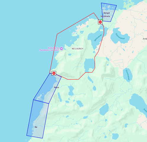
Road closure
County road 7698 will be closed between Nordmela community centre and Nøss. Detour via county road 82. Read more about the road closure here.
SMS service for road closures
Would you like up‑to‑date information on when the road closes and reopens? Subscribe to Andøya Space’s SMS service.
Send the keyword “ANDOYASPACE VEI START” to 27222 to subscribe.
Send the keyword “ANDOYASPACE VEI STOPP” to 27222 to unsubscribe.
You can also stay updated on the Norwegian Public Roads Administration website or app, where road and traffic information for all of Norway is continuously updated.
Airspace restrictions and camera surveillance
The area around the spaceport is a permanent airspace restriction zone, which means that all aircraft must apply for permission to use the airspace by sending an application to luftromskoordinering@andoyaspace.no.
The monitoring is carried out, among other things, using cameras. The purpose is to ensure life and health during operations with elevated risk. You can read more about camera surveillance here: andoyaspace.no/spaceport/privacy
Maritime danger areas
The following hazard areas will be established in connection with the launch:
Danger area sea, “SEA_UR”
| Coordinate number | Coordinate Lat-Lon (DDMM.M) |
|---|---|
| 1 | 6947.00N-01533.00E |
| 2 | 6948.00N-01609.00E |
| 3 | 6936.00N-01612.00E |
| 4 | 6935.00N-01538.00E |
| (1) | (6947.00N-01533.00E) |
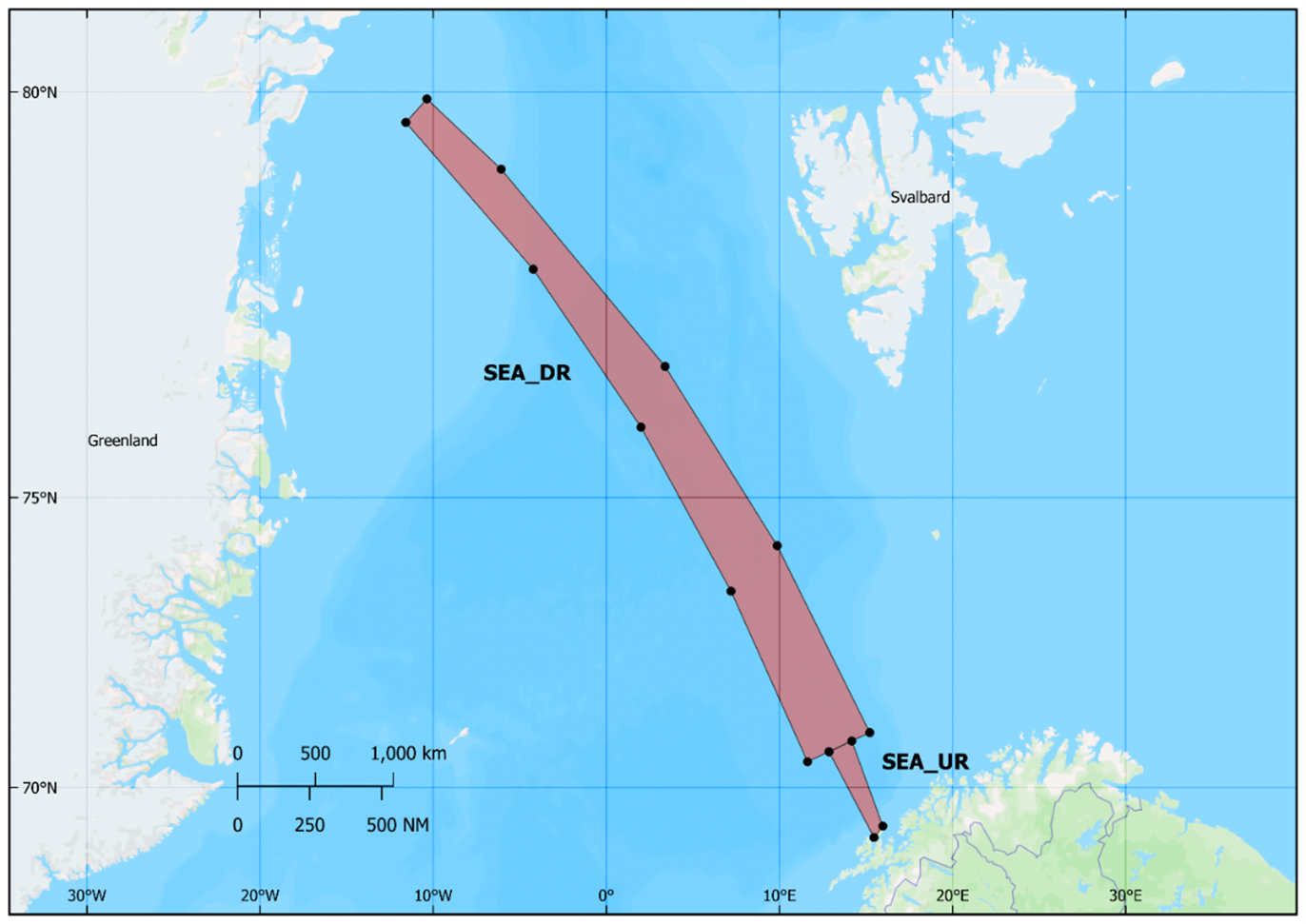
Danger area sea, “SEA_DR”
| Coordinate number | Coordinate Lat-Lon (DDMM.M) |
|---|---|
| 1 | 6947.00N-01533.00E |
| 2 | 6948.00N-01609.00E |
| 3 | 6936.00N-01612.00E |
| 4 | 6935.00N-01538.00E |
| 5 | (6947.00N-01533.00E) |
| 6 | |
| 7 | |
| 8 | |
| 9 | |
| 10 | |
| (1) |
SMS service for maritime areas
Would you like updated information about the maritime danger areas?
Send the keyword “ANDOYASPACE SJO START” to 27222 to subscribe.
Send the keyword “ANDOYASPACE SJO STOPP” to 27222 to unsubscribe.
Questions about coordination within the maritime danger areas?
Contact us at +47 73 60 70 64/+47 94 07 59 44 or via VHF channels 16/14 between 09:30 and 22:30 local time when the danger area is active.
Outside these hours, coordination requests can be sent to: mso@andoyaspace.no.
Norsk farevarsel
Det er planlagt operasjonelle aktiviteter i Børvågen i perioden 13. – 23. januar, 2026.
Dette vil føre til midlertidige stengninger av fylkesvei 7698, samt begrensninger i adgangen til deler av Børvågen-området. Det vil også bli etablert et maritimt faresoneområde.
I denne forbindelse vil Andøya Space iverksette en rekke sikkerhetsrelaterte tiltak. I hele perioden vil personell fra Andøya Space være til stede i de berørte områdene. De vil gi informasjon, råd og veiledning. Vi ber om at alle instruksjoner fra vårt personell blir respektert.
For mer informasjon om aktiviteten, vennligst besøk Isar Aerospace sine nettsider.
Faresoner, hensynssoner og veistengninger
Faresoner og hensynssoner er definert i forbindelse med operasjonene. Når den operative aktiviteten starter, vil disse områdene bli etablert og sikret av personell fra Andøya Space. Andøya Space vil benytte operatører, kameraer og droner for å sikre en trygg operasjon.
Hensynssoner
I henhold til våre sikkerhetsprosedyrer er antall personer som har adgang til områdene rundt faresonen begrenset. Disse områdene med begrenset kapasitet omtales som «hensynssoner».
Områdene med begrenset kapasitet er forbeholdt lokale innbyggere, og vi ber alle andre besøkende vennligst holde seg utenfor disse områdene. Dersom det befinner seg for mange personer innenfor disse sonene, vil vi ikke kunne gjennomføre oppskytingen.
Veistengning
Fylkesvei 7698 vil bli stengt mellom Nordmela samfunnshus og Nøss. Omkjøring via fylkesvei 82.
SMS-tjeneste for veistengninger
Ønsker du oppdatert informasjon om når veien stenges og gjenåpnes? Abonner på Andøya Space sin SMS-tjeneste.
Send kodeordet «ANDOYASPACE VEI START» til 27222 for å abonnere.
Send kodeordet «ANDOYASPACE VEI STOPP» til 27222 for å avslutte abonnementet.
Du kan også holde deg oppdatert via Statens vegvesens nettsider eller app, hvor vei- og trafikkinformasjon for hele Norge oppdateres kontinuerlig.
Luftromsrestriksjoner og kameraovervåkning
Området rundt romhavnen er en permanent luftromsrestriksjonssone, noe som betyr at alle luftfartøy må søke om tillatelse for å bruke luftrommet ved å sende en søknad til luftromskoordinering@andoyaspace.no.
Overvåkingen gjøres blant annet ved hjelp av kameraer. Hensikten er å sikre liv og helse under operasjoner med forhøyet risiko. Du kan lese mer om kameraovervåkingen her: andoyaspace.no/spaceport/privacy
Maritime fareområder
Følgende faresoner vil bli etablert i forbindelse med operasjonen:
Fareområde sjø, “SEA_UR”
| Coordinate number | Coordinate Lat-Lon (DDMM.M) |
|---|---|
| 1 | 6859.33N-1528.05E |
| 2 | 6913.37N-1558.52E |
| 3 | 7053.83N-1410.90E |
| 4 | 7041.62N-1251.94E |
| (1) | (6859.33N-1528.05E) |
Fareområde sjø, “SEA_DR”
| Coordinate number | Coordinate Lat-Lon (DDMM.M) |
|---|---|
| 1 | 7103.42N-1512.97E |
| 2 | 7415.83N-0952.26E |
| 3 | 7650.36N-0323.81E |
| 4 | 7911.76N-0604.25W |
| 5 | 7955.85N-1021.89W |
| 6 | 7941.45N-1134.89W |
| 7 | 7803.47N-0413.39W |
| 8 | 7601.02N-0200.03E |
| 9 | 7332.12N-0712.24E |
| 10 | 7030.12N-1137.50E |
| (1) | 7103.42N-1512.97E |
SMS-tjeneste for maritime områder
Ønsker du oppdatert informasjon om de maritime faresonene?
Send kodeordet «ANDOYASPACE SJO START» til 27222 for å abonnere.
Send kodeordet «ANDOYASPACE SJO STOPP» til 27222 for å avslutte abonnementet.
Spørsmål om koordinering innenfor de maritime faresonene?
Kontakt oss på +47 73 60 70 64 / +47 94 07 59 44, eller via VHF-kanal 16/14 mellom kl. 09:30 og 22:30 lokal tid når faresonen er aktiv.
Utenom disse tidene kan forespørsler om koordinering sendes til: mso@andoyaspace.no.
Mer informasjon?
Vennligst kontakt Isar Aerospace for spørsmål om aktiviteten.
Har du konkrete spørsmål om farevarselet, vennligst kontakt Andøya Space på spaceport@andoyaspace.no.
More information?
Please contact Isar Aerospace with questions regarding the activity.
If you have specific questions about this danger area notice, please contact Andøya Space at spaceport@andoyaspace.no.